Tuesday, April 15, 2008

What time is it?

When you’re traveling the world, do you have trouble keeping track of what time it is? If you’re flying, the crew generally tells you the local time at your destination. For those of us traveling by sailboat, it’s a little more complicated. A recent thread on the Yahoo! World-Cruising group about time coincided with our return to Mexico from Panamá and the western Caribbean islands. This and my mom’s question, “What time is it there?” prompted this meander.


When you’re at sea, it’s whatever time those on board agree that it is. However, since communication with others is important, some standards are useful. Our standard is Coordinated Universal Time or UTC. This is also known as GMT or Zulu time, but GMT can be confusing because that’s what the British and Irish call their time, but they use daylight savings time in the summer, and Zulu and UTC don’t. So we just call it UTC and keep one clock and the ship’s computer set to it. SSB radio schedules are usually given in UTC, and we report our position using it as well.
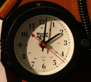
Our UTC clock at the nav station

When we left San Diego at the end of October on the Baja Ha-Ha 2007, the daily question was “What time is it here?” Every day the answer was “the same time as when we left San Diego.” But when we left San Diego, it was still Pacific Daylight Time (PDT), but in Baja California (the Mexican state), it was still Pacific Standard Time (PST) when we arrived at Cabo San Lucas. Across the Gulf of California in Mazatlán, it was Mountain Standard Time, which is actually the same as PDT, but by the time we got there, our family on the Pacific coast of the U.S. was back on PST, so there was still an hour’s difference. In Puerto Vallarta we were late to happy hour because there was a time change between La Cruz where the boat was and PV, which is on Central time. We don’t know if they use daylight savings because it was winter, so at least we avoided that complication. If this confuses you, then you know how we felt.

Time was easy for the rest of the winter (which they call summer in Central America even though it’s north of the equator, but that’s a different story). Central America is on Central time until you get to Panamá, which is on Eastern time.

When we left Panamá at the end of March, we were on Eastern Standard Time (EST), which seems to have been the time in Isla de Providencia and Grand Cayman too. At least, we met the agent in Providencia at the correct time, and the restaurant in Grand Cayman was still serving lunch when we got there. We stumbled across a cruising net on the SSB, though, an hour earlier than the time we had been told it was. Our fellow cruiser said it was Eastern time, but, oops, it’s April now, and it must be Eastern Daylight Time (EDT). (That’s why SSB radio information should always be given in UTC.)

But what time was it when we arrived at Isla Mujeres? One of our cruising guides said that Mexico and Belize don’t observe daylight time, so when I talked with Mom as soon as we arrived here, I thought it was Central Standard Time (CST), which would only be an hour different from the PDT in Portland, Oregon, at this time of year. Based on this information, John and I had agreed to leave our watches and local time clocks as they were because we were going back to Eastern time soon. No need to change, we thought. Boy, were we confused. When I finally looked it up on World Clock, it turns out that most of Mexico observes daylight time, so the cruising guide was wrong, and it’s Central Daylight Time (CDT) here. We don’t have to change our local time clocks now, but we will need to do that when we go to Florida where it’s EDT.

When it comes to time, it’s only going to get worse. For example, what will we use for local time as we cross the Atlantic? Someone on the World-Cruising group said that there are four time changes across the Atlantic. Looking at the map, I count five. And then someday when we get to India, we’ll have half-hour time differences, something I discovered when working for a global company. It’s a good thing the Internet is everywhere so we can be on time, whatever that is.

Sunday, April 13, 2008

Arrived Ahead of the Cold Front


The front we beat


We have arrived in Isla Mujeres (Island of Women) in Yucatan, Mexico. We beat the advancing cold front and the wind, rain, and building seas it will cause. The front is forecast for 20 knots from the north, which is opposed to the 2 knot current in the Yucatan Channel. The wind opposite the current will build up nine foot very steep wave. These waves would have been mostly on our beam and not comfortable.

It feels good to be back in Mexico. Almost like coming home back to the land of good food. On our first outing on the island we found a sidewalk BBQ stand. We purchased two orders of BBQ pork ribs with tortillas, beans, coleslaw, and salsa for seven dollars. The ribs are done with a chile and salt dry rub the coleslaw is cabbage with cilantro and jalapeño. Ah the flavors of Mexico! I'm sure there will be much more Mexican goodness to come.

We should be here about a week. We need to wait out the north winds before we head to Key West, Florida.

--John

Friday, April 11, 2008

Underway again

Grand Cayman was a nice place to visit and easy and cheap to clear in and out of. Actually, clearance is free if you do it during regular business hours. It's about the only thing that's inexpensive on the island, though. The people are very friendly and welcoming, but the prices are quite high. We did a little provisioning at a very nice store that was full of good things we hadn't seen in months, like Pepperidge Farm cookies, because our one visit to a restaurant cost us $45 US for two glasses of wine and a shared appetizer.

We wanted to stay a couple more days, and it wasn't the prices that scared us off. The long-range weather forecast (five-day) shows a front approaching from the north, and we definitely want to be across the Yucatan Channel at Isla Mujeres before northerly winds show up. By leaving Georgetown this morning, we should beat the front by more than a day. So far the winds are lighter than we had hoped, but we are sailing.
--Shirlee

Wednesday, April 9, 2008

Georgetown, Grand Cayman


Our previous record number of cruise ships sighted at anchor in one port (five in Ketchikan, Alaska) has been broken. There were six here yesterday. Port Security stopped by in the morning to tell us that we wouldn't be able to clear in until afternoon. No problem. John had a good wireless connection, and we didn't mind taking it easy.

It was fairly late in the afternoon when Port Security led us to the clearance wall. (I can't call it a dock because it's really just a concrete wall. We used all of our fenders to protect us.) The authorities were very nice, but it was the most thorough inspection we've had since the US. There was a delay due to Märzen because they had to call an inspector from the Department of Agriculture to look at her. In the end, she isn't allowed ashore because we didn't get an import permit for her, but we don't like to take her ashore in strange places anyway. She doesn't enjoy it, and it's a hassle.

The customs agents told us that the mooring buoys were available through Port Security and that the location was more convenient for provisioning than the other anchorage we had been considering. So we called Port Security, and they told us we can stay on a buoy for as long as we like for free! Clear-in and clear-out are also free if we do it during their regular hours. We're planning to stay until Friday or Saturday morning before heading for Isla Mujeres. John has already been snorkeling here and says there are some nice coral heads around the boat. We'll go exploring later.

Monday, April 7, 2008

Arrived at Grand Cayman

In our days in the Pacific, we estimated our passages based on the five knots we do under power. We have to stop doing that. Instead of the 74 hours we estimated, albeit conservatively, it would take us to get here from Providencia, it took just 58. That means that we arrived after dark at 8:30 instead of in the daylight. We didn't leave Providencia until after noon figuring we would be a little faster than estimated, but we set two new records for our daily speed on the way.

Whatever. We're here now, and after finding our way in the dark in yet another strange harbor, we're secured to a quarantine mooring buoy for the night. In the morning, customs and immigration will tell us where to go to clear in and when.

Sunday, April 6, 2008

Left Isla Providencia Headed for Grand Cayman

Isla de Providencia was beautiful. We wished we could have stayed there any another couple of weeks. Seems a lot of cruisers stop for a couple of days and stay for weeks. We just completed our fastest 24 hour passage at 6.7 kts average for 160.5 nautical miles. It's been a fast and wet ride so far.
--John
#END

----------
radio email processed by SailMail
for information see:

http://www.sailmail.com

Thursday, April 3, 2008

New photos on website

We're a bit Internet-challenged here in Providencia, but nonetheless, I've managed to upload some new photos to the website. Check them out at www.svsolstice.com/photos.html. Look under "Latest Additions."